Flood risk assessment review, from the planning advisor’s side of the desk
I review flood risk assessments the way the Environment Agency reads them: before you submit, after an objection, or for a parish council or planning authority that wants an independent view. From 2023 to 2025 I gave the Environment Agency’s planning advice on developments in and near Flood Zones in south London.
Real model output: a 1-in-100-year flood, plus 29% for climate change, spreading across the Hamstall Ridware floodplain in the first-generation 2022 model; 149 ha at its peak. Replayed, not to time scale. How to read this: drag the slider to move through the flood, hour by hour.
Animated map: in the 2022 model of a 1% AEP flood with a 29% climate allowance, water spreads over 79 hours to cover 149 hectares of the River Blithe and Trent floodplain at Hamstall Ridware, Staffordshire.
- tests a development in a Flood Zone can face: the sequential test, then the exception test
- 2
- years: the minimum lifetime to assume for new homes when choosing a climate allowance
- 100
- buildings flooded in the Hamstall model: the 1-in-100-year flood, then with the 2080s allowance
- 14 → 21
- deeper on the farmland opposite when one bank is raised to keep the village dry
- 0.01–0.06m
About the author. Hisham Nuhu is a UK-based flood and disaster risk specialist. He worked at England’s Environment Agency from 2019 to 2025 and holds an MSc in Water Science, Policy and Management from the University of Oxford. He works remotely or in-country with governments, development banks, UN agencies and consulting firms, and in England with councils, communities, landowners and developers.
Can someone independent review our flood risk assessment before we submit?
Yes. I read the assessment against the same tests the Environment Agency applies and tell you where it is likely to draw an objection, what to fix first and what is fine as it is. You get a short written review, with the issues ranked by risk to the application, and a call to talk it through.
In my experience the gaps that lead to objections are usually ordinary ones. The wrong climate allowance. An Environment Agency model used without checking that it suits the site. Nothing on how people get out when the road floods. Each is cheaper to fix before submission than after an objection.
I review for four kinds of client. The table shows what each one gets.
| Client | When | What I check | What you receive |
|---|---|---|---|
| Developer or planning consultant | Before you submit | The whole assessment: flood data, sequential and exception tests, climate allowance, modelling, floor levels, safe access and escape, flood risk elsewhere | The issues ranked by risk to the application, with suggested fixes, and a call |
| Developer after an objection | When the objection arrives | Each reason in the objection, and the evidence that would answer it | A response plan: what to submit, in what order, and whether new modelling is needed |
| Parish council or residents’ group | Before you comment on the application | Whether the developer’s assessment is sound, where it is weak, and what residents’ own records show | Plain-English comments you can submit to the planning consultation |
| Planning authority or lead local flood authority | While you are consulted | Flood risk assessments and the modelling behind them, where you want a second view | Review comments in your format |
What does the Environment Agency check in a flood risk assessment?
Whether the development will be safe for its lifetime without increasing flood risk elsewhere. In practice that means the right flood data and climate allowance, modelling fit for the site, finished floor levels above the design flood, safe access and escape, and the evidence for the sequential and exception tests where policy requires them.
The sequential test asks whether a site at lower flood risk is reasonably available. It is the planning authority’s decision, informed by the assessment. The exception test, where it applies, has two parts: wider benefits to the community that outweigh the flood risk, and a development that is safe for its lifetime, taking account of who will use it, without increasing flood risk elsewhere.
The Environment Agency comments on the flood risk evidence. If a council is still minded to approve major development in Flood Zone 2 or 3 against a sustained Environment Agency objection, it must refer the application to the Secretary of State for possible call-in.
How a flood risk planning decision is made, in five steps
Application and assessment
A planning application in an area at flood risk, with a site-specific flood risk assessment where policy requires one. For example, any development in Flood Zone 3b, or a site of 1 hectare or more in Flood Zone 1.
Consultation
The council consults the Environment Agency as statutory consultee on the flood risk areas the rules specify. My role in south London, 2023–25.
Sequential test
Is a site at lower flood risk reasonably available? The planning authority decides. More modelling does not change this answer.
Exception test
Where it applies: wider benefits that outweigh the flood risk, and safe for its lifetime without increasing risk elsewhere. Both parts must be passed.
Response
No objection, conditions, or an objection with reasons. A sustained objection to major development can go to the Secretary of State.
How to read this: the steps light up in turn; tap or tab to any step to read it.
Sources
Planning Practice Guidance: flood risk and coastal change (MHCLG); Flood risk assessments: applying for planning permission (Environment Agency). Schematic based on public sources.
| Check | The question it answers | A common gap |
|---|---|---|
| Flood data | Is the risk described from the best data available for the site? | The Flood Map for Planning alone, where detailed Environment Agency data (Product 4) exists |
| Climate allowance | Is it the right allowance for the flood zone, the use and the lifetime? | The wrong category or lifetime; new homes need at least 100 years |
| Modelling | Is the model fit for this site and this question? | An Environment Agency model used unchanged, although such models “are not designed to assess third party developments” |
| Floor levels | Are finished floor levels above the design flood level, with a margin for uncertainty? | Levels set against a flood level that leaves out the climate allowance |
| Safe access and escape | Can people get in and out during the design flood? | A route dry at the front door but flooded at the end of the road |
| Flood risk elsewhere | Does the scheme push water onto anyone else? | Raised ground or walls with no check of the water they displace |
| Residual risk and warning | What happens if a defence is overtopped or breached, and will people get a warning? | Nothing on breach, and no flood warning and evacuation plan where one is needed |
The common gaps come from my experience as a planning advisor, not from statistics.
Which climate change allowance applies to our development?
It depends on the flood zone, how vulnerable the use is and how long the development will last. For most development in Flood Zones 2 and 3a, the Environment Agency’s guidance uses the central allowance for peak river flow; essential infrastructure uses the higher central. New homes are assumed to last at least 100 years.
The allowances are set for each management catchment, so the same development needs a different uplift in different parts of the country. At Hamstall Ridware, in the Trent Valley Staffordshire catchment, the central allowances I used for peak river flow were +15% for the 2020s, +17% for the 2050s and +29% for the 2080s. The upper end for the 2080s is +61%.
The figure shows why the choice matters. In the same village, the 1-in-100-year flood reaches 14 buildings. With the 2080s allowance it reaches 21, and the deepest water at a building rises from 0.13 m to 0.34 m.
Fourteen buildings flooded, or 21: the climate allowance decides
How to read this: each bar is one modelled flood; the gauge on the right (wide screens) or the readout (phones) shows the deepest water at any building. Tap a bar or a button to step through.
Hamstall Ridware, 2024 model (Flood Modeller–TUFLOW, 5 m grid), built jointly with an Environment Agency modelling colleague: buildings flooded in the 1-in-100-year flood, with the 2020s, 2050s and 2080s allowances, and in the 1-in-1,000-year flood.
Show the data as a table
| Flood | Buildings flooded | Deepest at a building, m | 0.1 m or deeper | 0.3 m or deeper |
|---|---|---|---|---|
| 1% AEP flood (1 in 100) | 14 | 0.13 | 1 | 0 |
| 1% AEP + 15% (2020s allowance) | 16 | 0.24 | 8 | 0 |
| 1% AEP + 17% (2050s allowance) | 19 | 0.31 | 9 | 1 |
| 1% AEP + 29% (2080s allowance) | 21 | 0.34 | 9 | 1 |
| 0.1% AEP flood (1 in 1,000) | 29 | 0.46 | 17 | 5 |
How do you show a development does not increase flood risk elsewhere?
Model the flood with and without the scheme and map the difference: where land is newly wet, where water is deeper, and whose homes or fields those places are. If anything gets worse, the design has to change or include mitigation, such as floodplain compensation, before the assessment can say the risk elsewhere does not rise.
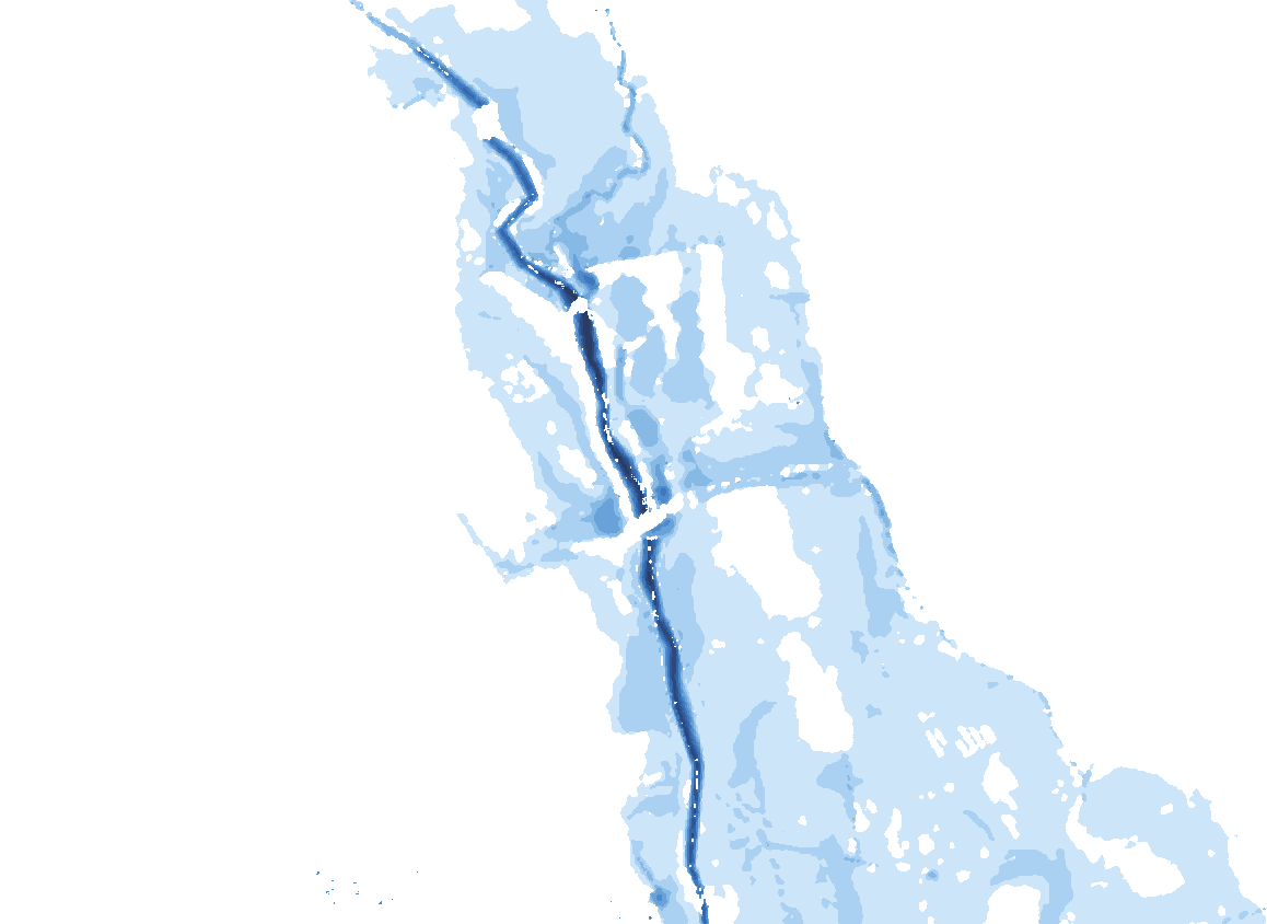
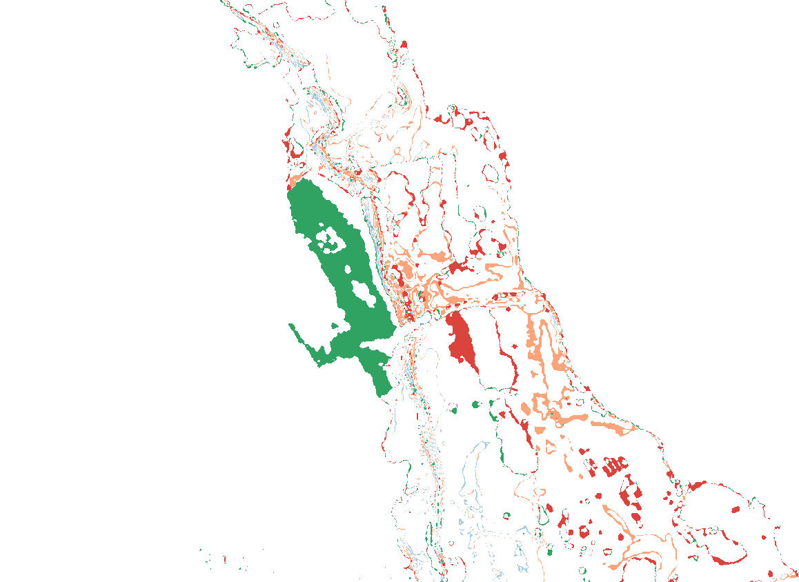
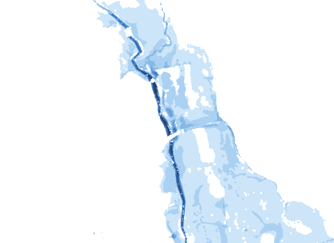
The Hamstall model shows what that test looks for. Raising the right bank keeps the village dry in every flood modelled, up to the 1-in-1,000-year event. But the water has to go somewhere. It spreads across the farmland opposite, typically 0.01–0.06 m deeper.
At Hamstall the extra water fell on farmland, so the farmers had to be part of any solution. In a planning application the same map is the evidence an assessor asks for: drag the handle and you can see exactly where the risk moves.
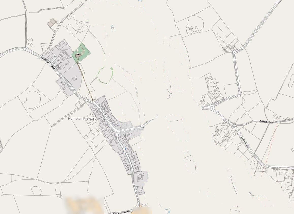
Raise one bank and the water moves: the village stays dry, the farmland opposite gets wetter
 Today
Change with the raised bank
Modelled depth, m (left of the handle, and “Depths with the raised bank”)
Change with the raised bank (“Show the change”)
- Newly wet
- Deeper
- No longer wet
- Shallower
How to read this: drag the handle, or use the arrow keys. Left of the handle is today’s flood. Right of it is the change the raised bank makes: red is newly wet, orange is deeper, green is no longer wet.
Event: 1-in-100-year flood plus a 15% climate allowance, in the 2024 model I built jointly with an Environment Agency modelling colleague. The raised right bank keeps the village dry; the water moves to the farmland opposite.
Sources
Flood depths: Environment Agency 2024 model; depth classes recovered from the report maps. Wet-area changes are approximate (about 3.7% less wet area overall). Basemap © OpenStreetMap contributors (flood colours removed, farm labels blurred).
The Environment Agency has objected. What should the response contain?
An answer to each reason in the objection, with evidence rather than argument. Usually that is a revised assessment or a technical note; sometimes it is new or updated modelling. Where modelling is involved, the Environment Agency’s own charged planning advice service can look at it before you resubmit, which may speed up its review.
Read the objection as a checklist. Each reason names a missing piece of evidence. The response should answer them one for one, in the same order, so the officer can see that each has been dealt with.
If the objection is about modelling, first check whether the model can answer the question at all. GOV.UK puts that on the applicant: “It’s your responsibility to check the suitability of an existing model for your development.”
If the objection is about the sequential test, more modelling will not help. That test is about whether a site at lower risk is reasonably available, not about how well the flood is described.
Can a parish council get an independent view on a developer’s flood risk assessment?
Yes. I read the developer’s assessment, the consultee responses and residents’ own flood records, and write plain-English comments the parish can submit to the planning consultation. If the assessment is sound, I say so. That is worth knowing too, before the parish spends its credibility on an objection that will not stand.
Residents often know things an assessment does not: which road floods first, where water came over the bank, how deep it was last time. At Hamstall Ridware, residents’ records of the February 2020 flood were how I checked the model, because the village gauge is bypassed in big floods. The same kind of record can test a developer’s assessment.
Comments carry most weight when they are specific: the paragraph, the evidence that contradicts it, and what the parish asks the council to require. How residents’ records become evidence.
Can you also prepare a flood risk assessment or a flood warning and evacuation plan?
Yes, where the site needs real hydrology or modelling: a river site with no usable model, a site below a reservoir, or a scheme that changes flood levels. I can also write a flood warning and evacuation plan, drawing on ten incident weeks as an Environment Agency Flood Warning Duty Officer in south-east London.
On duty I turned forecasts and overnight river-level alerts into flood alerts and warnings, as the risk level moved between yellow and red, and kept police and ambulance services involved. A plan for a development has to work for the people who will receive those messages: what each one means for them, where they go, and when.
The meanings are short. A Flood Alert means flooding is possible, so prepare now. A Flood Warning means flooding is expected, so act now. A Severe Flood Warning means flooding could be a risk to life and cause significant disruption to communities.
What does a review cost, and how long does it take?
A fixed fee, agreed before I start, set by the length of the assessment and whether a model has to be checked as well. Send me the assessment and the planning reference, and I will reply with the scope, the fee and a date for the review.
Reviews that include modelling take longer, because the model files (Environment Agency Products 5 to 7, or your consultant’s own) have to be obtained and checked.
Questions people ask
Did you review flood risk assessments at the Environment Agency?
Yes. From 2023 to 2025 I gave planning advice on developments in and near Flood Zones in south London, as part of the Environment Agency’s statutory consultee role, and reviewed assessments against national policy, including the exception test, and the climate change allowances. Individual cases are not published.
Is a review from you a form of Environment Agency approval?
No. I left the Environment Agency in 2025 and do not speak for it. A review is my independent opinion; the Environment Agency and the planning authority make their own decisions.
Can you guarantee an objection will be withdrawn?
No one honestly can. I can tell you what evidence the objection asks for and help make that evidence complete and clear.
Do you work outside London?
Yes, anywhere in England. I worked in the West Midlands from 2020 to 2023 and in London from 2023 to 2025. Reviews are done remotely, with a site visit where it helps.
What should I send you?
The flood risk assessment, the planning reference, any consultee responses and the model report if there is one.
Related work
Work · West Midlands and south London
Flood risk permits, planning advice and the Water Framework Directive
The decision path I worked within as a planning advisor, and the permit route for works near rivers.

 Options tested in the 2024 model
Case study · Staffordshire
Hamstall Ridware: keeping a village dry below a reservoir
Where the flood risk moves when one bank is raised, and why the farmers’ bund worked.
Work · South-east London
Flood Warning Duty Officer
Ten incident weeks issuing flood alerts and warnings, with police and ambulance services kept involved.
Sources
- Ministry of Housing, Communities and Local Government (2025). Flood risk and coastal change: Planning Practice Guidance. GOV.UK, updated 17 September 2025. Sequential and exception tests, site-specific assessments, Secretary of State referral.
- Environment Agency (2026). Flood risk assessments: applying for planning permission. GOV.UK. When an assessment is needed; Products 1 to 8; the limits of existing models.
- Environment Agency. Flood risk assessments: climate change allowances. GOV.UK. Which allowance applies, and the 100-year minimum lifetime for homes.
- Defra and Environment Agency (2023). Using modelling for flood risk assessments. GOV.UK. Model suitability, review and the charged modelling advice.
- Environment Agency (2026). Flood and coastal risk products: submit an evidence review request. GOV.UK, 21 September 2026. The discretionary, charged planning advice service for modelling.
- Environment Agency. Flood alerts and warnings: what they are and what to do. GOV.UK.
Work with me
Have an assessment to check?
Send me the flood risk assessment, the planning reference and any consultee responses. I will reply with a scope, a fixed fee and a timescale. I don’t take on work on cases I handled while at the Environment Agency.