Village flood studies: from residents’ records to protection that gets built

A village flood study answers three questions in order: where the water comes from, what would keep it out of homes, and who could pay for it. At Hamstall Ridware in Staffordshire, a village below a reservoir, the answers ran from residents’ records of the February 2020 flood to an earth bund the farmers built.

T+79 h149 ha flooded

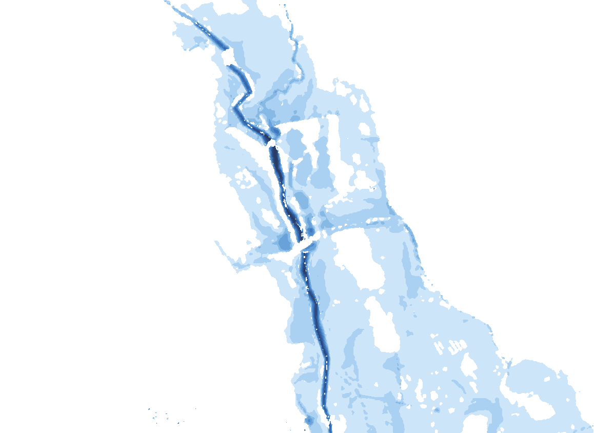
Real model output: a 1-in-100-year flood, plus 29% for climate change, spreading across the Hamstall Ridware floodplain in the first-generation 2022 model; 149 ha at its peak. Replayed, not to time scale. How to read this: drag the slider to watch the flood spread from the river across the fields.

Animated map: in the 2022 model of a 1% AEP flood with a 29% climate allowance, water spreads over 79 hours to cover 149 hectares of the River Blithe and Trent floodplain at Hamstall Ridware, Staffordshire.

of catchment drain to Hamstall Ridware, three-quarters of it through Blithfield Reservoir
163km²
homes residents reported flooded on three roads in February 2020, against 14 in the model
11
buildings flooded in the 1-in-100-year flood with the 2080s climate allowance, in the 2024 model
21
benefit–cost ratio of an earth bund in my own appraisal, against 1.6 for a wall
4.6

About the author. Hisham Nuhu is a UK-based flood and disaster risk specialist. He worked at England’s Environment Agency from 2019 to 2025 and holds an MSc in Water Science, Policy and Management from the University of Oxford. He works remotely or in-country with governments, development banks, UN agencies and consulting firms, and in England with councils, communities, landowners and developers.

Our village keeps flooding. How do we get a flood scheme?

Build the evidence, then get the right authority to carry it. Record every flood. Ask the lead local flood authority, or the Environment Agency for a main river, to look into it. Commission a study that tests options. Then bid for funding with partners: most government flood money goes through those authorities, so they need to own the case.

The route has six steps. Residents can start the first two today. The table shows who usually leads each one, and where an independent hydrologist and modeller helps.

The route from a flooded village to a scheme that gets built
StepWhat happensWho usually leadsWhere I can help
1. RecordPhotos, flood marks, depths, dates, and which homes flooded insideResidents, the flood group, the parish councilA short questionnaire and a record a model can be checked against
2. ReportThe flooding is reported and looked intoThe lead local flood authority, or the Environment Agency for a main riverPutting the residents’ evidence in a form the authority can use
3. StudyWhere the water comes from; hydrology and a model; options testedThe authority, or the parish with partnersHydrology, modelling and options, written up in plain English
4. AppraiseThe costs and benefits of each option, on one basisThe authorityA consistent appraisal that counts harm to mental health
5. FundThe project is put forward for government funding, with partners’ contributionsThe authority, with partnersA case built for the funding policy in force since April 2026
6. Build and look afterWorks designed, permitted, built and maintainedThe authority, landownersChecking the design does not move the water onto neighbours

What does a village flood study involve?

Five steps, each feeding the next: the catchment, the hydrology, a computer model of the river and village, the options, and what gets built. At Hamstall Ridware the hydrology was entirely my work, and I built the 1D–2D model jointly with an Environment Agency modelling colleague. Scroll through the study as it happened.

Fig. 1 · Step by step

Hamstall Ridware: from the catchment to a farmers’ bund

Scroll through the five steps; in step 3, scrolling runs the flood hour by hour.Choose a step; in step 3, drag the hour slider to run the flood.

Four sub-catchments drain to the village

Schematic of the 163 km² catchment: the area upstream of Blithfield Reservoir (119.7 km²), Ash Brook (12.8 km²), Pur Brook (15.7 km²) and the intervening area to the village (14.5 km²).

The design flood flowing into the reservoir, 1-in-100-year event

2022 model: 1-in-100-year flood + 29% climate allowance, 6 m grid

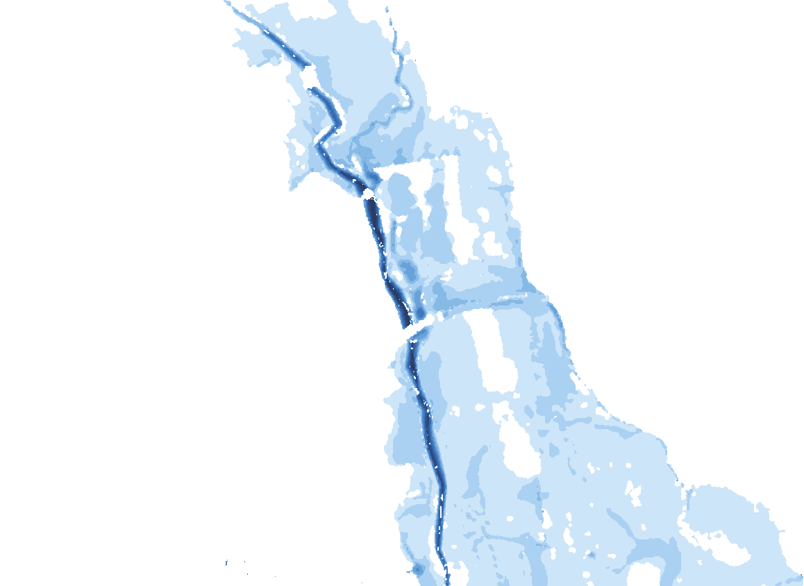
1-in-100-year flood + 15% (2024 model): today and with the raised bank

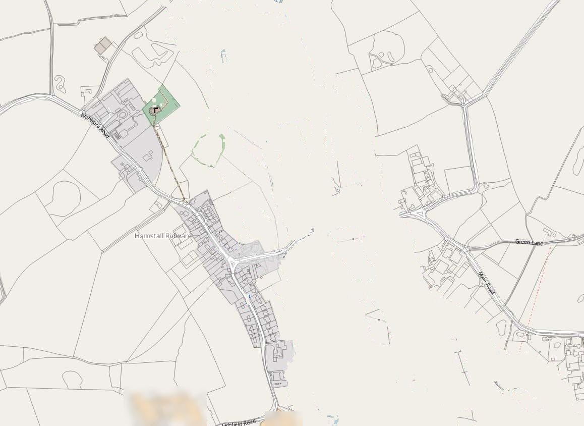
Basemap: Hamstall Ridware, the River Blithe and the surrounding farmland (OpenStreetMap) Today’s modelled flood depths: water crosses the right bank into the village. Modelled flood depths with the right bank raised: the village stays dry and the water spreads across the farmland opposite. Raised bank Today

Flood depths: Environment Agency 2024 model, built jointly by me and an Environment Agency modelling colleague. Basemap © OpenStreetMap contributors.

Benefit–cost ratio of three options, on one standard basis

My own cost–benefit appraisal (self-initiated, not a formal Environment Agency submission), at screening level on a standard basis.

Step 1 of 5 · Catchment

Where the water comes from

163 km² of farmland drains to the village down the River Blithe. Three-quarters of it passes through Blithfield Reservoir first, and in big floods the water goes round the village gauge. So the gauge record could not be trusted on its own.

163 km²draining to the village, about 75% of it through the reservoir

Step 2 of 5 · Hydrology

How big a flood to plan for

I compared three standard ways of estimating a rare flood and built the design flood from the most defensible parts of each. The 1-in-100-year flow came out about half as big again as the gauge record alone suggested.

44.6 m³/s1-in-100-year flow to the village, against 30.0 from the gauge record

Step 3 of 5 · Model

Watching the flood spread

A computer model shows where the water goes, field by field. The river and its bridge are modelled in one dimension, the floodplain and the village in two. I checked it against residents’ records of the February 2020 flood. Keep scrolling to run the flood.

149 haflooded by hour 79 in the 2022 run, with the 2080s climate allowance

Step 4 of 5 · Options

Testing ideas before anyone builds

The 2024 model tested two ideas. Opening the second arch of the road bridge made no difference upstream. Raising the right bank kept the village dry in every flood modelled, but moved the water onto the farmland opposite.

Village drywith the right bank raised, in every flood modelled up to 1 in 1,000

Step 5 of 5 · Outcome

A bund the farmers built

In my own cost–benefit appraisal (self-initiated, not a formal Environment Agency submission), an earth bund on that line came out far ahead of a wall or an embankment. Separately, the farmers built an earth bund of their own, working with landowners and the village. Its design and cost were not recorded, so the ratio is not a measure of it.

4.6benefit–cost ratio of an earth bund (3.3–7.0 across unit rates), against 1.6 for a wall and 1.0 for an embankment

Sources

My flood estimation record v4 (2025); the Environment Agency 2024 model, built jointly by me and an Environment Agency modelling colleague; the 2022 Flood Modeller 2D run, drawn from its arrival-time and maximum-depth grids; my own screening-level appraisal on a standard basis. Basemap © OpenStreetMap contributors.

How do residents’ photos and records help?

They are often the best flood data a village has. At Hamstall Ridware the gauge is bypassed in big floods, so I checked the model against a residents’ questionnaire about February 2020: 11 homes reported flooded on three roads, 14 in the model. Two depths residents measured gave a further check.

What to record during or soon after a flood: the date and time; where the water came from and which way it went; depths against something that will still be there, such as a doorstep or a wall; photos with the time on them; and which homes flooded inside. A rough record is worth having, as long as it is honest about what it does not know.

The match does not need to be perfect. It needs to be close enough to trust the model for the decision. At Hamstall I raised the channel roughness in the wooded reaches, from 0.03 to 0.075, to match what residents saw.

Fig. 2

February 2020: what residents reported, and what the model showed, road by road

How to read this: each pair of bars is one road: residents’ reports on the left, the model on the right. Hover or tap a bar for the questionnaire notes.

Community flood questionnaire and the 2022 Flood Modeller model of the February 2020 flood (gauge peak 20.8 m³/s).

Show the data as a table
February 2020 flood: homes reported flooded by residents and homes flooded in the 2022 model, by road
RoadReported by residentsFlooded in the modelQuestionnaire
Street A571 household did not respond
Street B352 households did not respond
Street C32all households responded

Totals: 11 reported, 14 in the model. Roads are labelled generically and no property is named.

Can farmers and landowners build a flood bund?

Yes, and at Hamstall Ridware they did. But a bund changes where water goes, so it needs the right permissions and a check that it does not push the flood onto someone else. Work within 8 metres of a main river, or on its floodplain without planning permission, needs a flood risk activity permit unless it is excluded or exempt.

On an ordinary watercourse, a stream or ditch that is not a main river, ask the council or internal drainage board whether you need land drainage consent instead. Check with the council whether the works need planning permission too.

The harder question is the neighbours. In the 2024 Hamstall model, raising the right bank kept the village dry but put more water, typically 0.01–0.06 m deeper, on the farmland opposite. That is why the farmers had to be part of any solution. I assessed flood risk activity permits in the West Midlands from 2020 to 2023, and that transfer of risk is exactly what an assessor looks for.

Who pays for a village flood study and the works?

Usually a mix. Government flood funding goes mainly to projects put forward by councils, the Environment Agency, internal drainage boards and water companies, and since April 2026 it is prioritised by how much benefit each pound of government money buys. Money from the parish, landowners and businesses still matters, and community groups can lead small natural flood management projects.

Under the policy in force since April 2026, partners’ money does two jobs. It lowers the government’s share, which raises the project’s score, and “additional contributions” is one of the strategic objectives the Environment Agency looks for.

Standalone natural flood management projects under £3 million can be put forward by community groups, charities, farmers and landowners, through an NFM project opportunity form sent to the Environment Agency. A study can be commissioned by the parish, the council or both. What matters is that the authority can take it straight into a funding bid. How flood schemes are funded in England.

How long does a study take, and what does it cost?

It depends most on whether a model already exists. If the Environment Agency holds a river model for the village, a study can start from it; if not, it needs survey and a new model. After a scoping call I give a fixed fee and a timescale in writing, before any work starts.

Start by asking the Environment Agency what it already holds for the village: Products 4 to 7 cover detailed flood data, model reports, model outputs and model inputs. Hamstall’s modelling would have cost an estimated US$100k if contracted externally. Many village questions are smaller: a review of what exists, a hydrology update, or one option tested in an existing model.

Questions people ask

What do Flood Alert, Flood Warning and Severe Flood Warning mean?

A Flood Alert means flooding is possible, so prepare now. A Flood Warning means flooding is expected, so act now. A Severe Flood Warning means flooding could be a risk to life and cause significant disruption to communities. You can sign up for free warnings by phone, text or email on GOV.UK (“Sign up for flood warnings”), or call Floodline on 0345 988 1188.

Does a study guarantee that a scheme gets built?

No. It gives the authority and the funders the evidence to decide. At Hamstall the study pointed to holding the right-bank line; the farmers then built a bund, working with landowners and the village.

A developer wants to build on fields that flood. What can the parish do?

Comment on the planning application with specific, evidenced points. I can review the developer’s flood risk assessment and help you write those comments. Flood risk assessment reviews.

Do you work with flood action groups?

Yes. A group’s records, local knowledge and contact with landowners are what make a study work. At Hamstall Ridware the residents’ own questionnaire about the February 2020 flood was what let me check the model.

Do you only work in Staffordshire?

No, anywhere in England. Most of the analysis is remote; I come to the village for site visits and parish meetings.

Sources

  1. UK Centre for Ecology & Hydrology. National River Flow Archive, station 28002: Blithe at Hamstall Ridware. The gauge record behind the hydrology.
  2. Environment Agency and Defra (2026). Flood risk activities: environmental permits. GOV.UK, updated 9 October 2026. When works near a main river need a permit; land drainage consent for ordinary watercourses.
  3. Environment Agency (2026). Flood and coastal erosion risk management funding policy guidance. GOV.UK, published 3 March 2026, updated 1 April 2026.
  4. Environment Agency (2026). Flood risk assessments: applying for planning permission. GOV.UK. Products 4 to 8.
  5. Environment Agency (2021). Mental health costs of flooding and erosion. GOV.UK.
  6. Environment Agency. Flood alerts and warnings: what they are and what to do. GOV.UK.

Work with me

Is your village asking why it floods?

Send me what you have: photos, dates, the homes affected, any council or Environment Agency reports. I will reply with a scope, a fixed fee and a timescale. I don’t take on work on cases I handled while at the Environment Agency.